|
Location: 56-km
South West Of Srinagar, Kashmir Region, J&K
Main Attractions: Alpather Lake, Golf Courses & Skiing
Altitude: 2,730m
Best Time To Visit: In Summer - May To September
In Winter - November To February
The Meadow Of Flowers
A huge cup shaped meadow, lush and green with slopes where th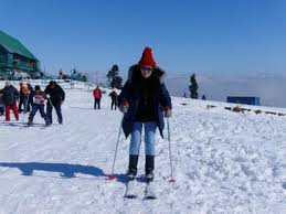 e
silence is broken only by the tinkle of cowbells, Gulmarg looks
like a fantasy set in a film and not surprisingly have been the
venue of several films. e
silence is broken only by the tinkle of cowbells, Gulmarg looks
like a fantasy set in a film and not surprisingly have been the
venue of several films.
The valley of Gulmarg, a large meadow about 3-sq-kms in area,
stands at 2,730 metres, 56-km south west of Srinagar . The name
means 'Meadow Of Flowers' and in the spring it's just that, a
rolling meadow dotted with countless colourful Bluebells,
Daisies, Forget Me Not's and Buttercups. The valley itself is
about 3-km long and up to a km wide.
Take a Hike!
All around are snow-capped mountains, and on a clear day one can
see all the way to Nanga Parbat is one direction and Srinagar is
another. It's a popular day trip from Srinagar to Gulmarg,
although many people extend their stay or use it as a base for
trekking. The road from Srinagar rises gently towards the lower
slopes of the range, passing through rice and maize fields.
From Tangmarg, at the foot of the range, there are two paths to
Gulmarg - a steep footpath or a winding sealed road. There is
also a pony track from Gulmarg that leads upwards to Khilanmarg,
Kongdori and seven springs.
PRIME ATTRACTIONS
Khilanmarg
This smaller valley is about a 6-km walk from the Gulmarg b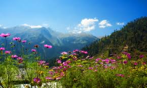 us
stop and car park. The meadow, carpeted with flowers in the
spring, is the site for Gulmarg's winter ski runs and offers a
fine view of the surrounding peaks and over the Kashmir Valley.
It's a 600-metre ascent from Gulmarg to Khilanmarg and during
the early spring, as the snow melts, it can be a very muddy
hour's climb up the hill. The effort is rewarded, if it's clear,
with a sweeping view of the great Himalayas from Nanga Parbat to
the twin 7,100-metre peaks of Nun and Kun to the southeast. us
stop and car park. The meadow, carpeted with flowers in the
spring, is the site for Gulmarg's winter ski runs and offers a
fine view of the surrounding peaks and over the Kashmir Valley.
It's a 600-metre ascent from Gulmarg to Khilanmarg and during
the early spring, as the snow melts, it can be a very muddy
hour's climb up the hill. The effort is rewarded, if it's clear,
with a sweeping view of the great Himalayas from Nanga Parbat to
the twin 7,100-metre peaks of Nun and Kun to the southeast.
Alpather Lake:
Beyond Khilanmarg, 13-km from Gulmarg at the foot of the twin 4,
511 metre Apharwat peaks, this lake is frozen until mid-June and
even later in the year one can see lumps of ice floating in its
cold waters. The walk from Gulmarg follows a well-graded Pony
track over the 3, 810 metre Apharwat ridge, separating it from
Khilanmarg, and then up the valley to the lake at 3,843 metres.
The more adventurous trekkers can climb straight up the
boulder-strewn slope of the ridge and descend the other side to
the path. For horse riding aficionados, Alpather Lake makes an
exciting day's excursion, starting early morning and returning
late evening.
The Ningli Nallah:
Flowing from the melting snow and ice on Apharwat and the
Alpather Lake, this pretty mountain stream is 8-km from Gulmarg.
The stream continues down into the valley below and joins the
Jhelum River near Sopur. This long, grassy valley is a popular
picnic spot and the walking path carries on, crossing the Ningli
(also spelt as Ningle) Nallah by a bridge and continues on to
the Khilenmarg, another grassy meadow and a good spot for
camping. In early summer one will probably share the campsites
with Gujars moving their herds up to the high meadows.
Ferozpore Nallah
Reached from the Tangmarg road, or from the Outer Circular Walk,
this mountain stream meets the Bahan River at a popular picnic
spot known as 'waters meet'. The stream is reputed to be
particularly good for trout fishing; it's about five km down the
valley from Gulmarg but quite close to Tangmarg. The river can
be reached by walking 3-km down the path from the gap near
Tangmarg and then heading south through the forest, down a slope
towards the stream.
Near here there is a bridge which leas to the small waters meet
picnic spot on the right bank. Looking south from Tangmarg the
river can be traced up to its source close to the rugged peak
known as Ferozpore or Shinmahinyu. On the right bank the stream
branches, the left path leading to Tosa Maidan, while the right
bends away towards the Gogaldara road at a second bridge, about
32-km upstream, and then leads away to the Ferozpore pass,
Poonch and Kantar Nag.
One can continue on from here to Tosa Maidan, a three day, 50-km
walk to one of Kashmir's most beautiful Marg's, crossing the
Basmai Gali pass at about 4,000 metres. The track here is very
close to the ceasefire line with Pakistan and on the right one
will pass the Jamainwali Gali, the pass at 4,000 metres is one
of the easiest and safest routes into the Punjab.
Shrine Of Baba Reshi / Ziarat Of Baba Reshi :
This Muslim shrine is on the slopes below Gulmarg and can be
reached from either Gulmarg or Tangmarg. The Ziarat, or tomb, is
of a well-known Muslim saint who died here in 1480. Before
renouncing worldly ways he was a courtier of the Kashmir King
Zain-ul-Abidin. Every year thousands of devotees visit this
shrine regardless of the faith they believe in.
Skiing:
Please Click Here to Big Picture -January SeasonIn winter,
Gulmarg acquires a new persona - that of the country's premier
skiing resorts. Skiing, to many who watch it on TV, seems like a
very elitist sport, requiring a high level of training and
expensive equipment. They are surprised, when they visit Gulmarg
for a day's expedition to "see the snow", that others with the
same level of physical fitness and training are skiing down
slopes. Gulmarg is the ultimate beginner's skiing resort. One
doesn't requite a heavy woolen wardrobe - slacks or a Salwar
Kameez will do fine. In Gulmarg one will also be able to drift
to one of the many Ski shops and hire skis, sticks and goggles.
Just find yourself a ski instructor and set off down a slope.
Neither does one need to exert oneself climbing up slopes. The
gentlest slope of 200m is linked with a ski lift, which helps
one to go up. When one graduates to intermediate level - which
will happen after the first few days of practice, there are
other slopes, longer and steeper, which are connected by chair
lift. The longest ski run in Gulmarg is provided by the Gondola
cable car, which allows a ski run of 2,213m.
GULMARG WALKS
Outer Circular Walk:
A circular road, 11-km in length, runs right round Gulmarg
through pleasant pine forests with excellent views over the
Kashmir valley. Nanga Parbat is clearly visible 137-km to the
north, Haramukh 60-km to the east while to the south one can see
the Ferozpore and Sunset Peaks and the Apharwat Ridge. Nanga
Parbat, the 'lord of the mountains', is the fourth highest peak
on earth at 8,500 metres.
HOW TO GET THERE
Air: Gulmarg is in Baramula District and is 56-kms from Srinagar
District . The nearest Airport from here is situated in Badgam
District, which is well connected with all the major cities of
the country.
Rail: The nearest railhead is at Jammu.
Road: The journey from Srinagar to Gulmarg takes approximately 2
hours in bus and may take short time by chartered conveyance.
The road to Gulmarg is very beautiful and is lined with poplar
trees all through. All sorts of transport are available to
Gulmarg from Srinagar bus stand at Batmallo and from private
transport operators.
WHERE TO STAY
There are numerous hotels of various standards available for
accommodation purpose in Gulmarg, some of them being luxury,
several being comfortable in addition to JKTDC's winterized,
fully furnished huts, which are great value for money.
Assistance for booking accommodation can be had from the booking
manager at Tourist reception centre in Srinagar.
NEARBY CITIES : Srinagar : 56-km
|